i-Boating: One of the Best Navigation Route Apps
As the Maritime Goods blog team, we have examined one of the best navigation applications by researching the applications that offer the most efficient navigation, direction finding, and route options for individual use. Let's get to know this application together and discover its capabilities.
Automatic Route-to-Route Boat Guidance in i-Boating; If you're not sure how to find the best navigation route for your next boating vacation, we understand that planning the optimal navigation route between your departure point and your destination can be stressful. Therefore, we would like to introduce you to our new partner, i-Boating. An app where you can find the best and safest route to get the most out of your next boat trip.
The world-class nautical navigation app, i-Boating, has a nifty feature that automates the tedious job of routing. All you have to do is enter the draft of your boat, that is, the height of the part of the boat below the water level, and the application will automatically create the most suitable route between the start and destination point.
i-Boating includes a large database of hazards and obstacles created from official Electronic Navigation Charts (ENCs), custom surveys, and user-reported/verified hazards. This database is used by the route finder to create a route that avoids these navigation hazards. In this way, the route it offers you has a wonderful feature that will take you to the point you want to reach on the safest route, with a route suggestion that will take you away from the dangers that have been experienced before and the previously known dangerous areas.
The Part of the Boat Below Sea Level Will Be Safe; The i-Boating cartography team has created a unified bathymetry (depth) database for waters in the United States, Canada, Europe, Australia, the Caribbean, and popular boating, sailing, and fishing destinations around the world. The depth layer is used to establish a safe route for the boat's draft. In the absence of such a course, all shallow course legs are marked in red.
The auto-generated route is optimized for distance, time, and fuel consumption. The auto-routing tool menu includes a calculation feature for time and fuel estimates.
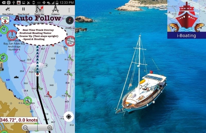
You can use your device's GPS to follow the created route. Course assist displays your boat's position on the screen, along with a course track that shows where your boat has been before, and an arrow showing where the boat is headed. The route assistance module allows you to follow the created route and gives an audible warning when you go off the route. It shows the distance to the next waypoint and the destination along with an ETA at the top of the screen. This easy-to-use and useful application guides you to the point you want to reach with the most ideal route without leaving your route.
As Maritime Goods blog, we recommend you use one of the best routing applications that are easy to use and vital for marine vehicles. You can download the application for free on iOS and Android markets. For now, the app is published in 9 languages. May your bow be clear.
Google Play Store: link
Apple App Store: link